In the Kannuskoski region, you can get to know the great excursion destinations of Väliväylä riverside.
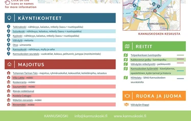
The areas of Kyykoski, Sulunkoski and Taikinakoski are beautiful places to visit. For visitors traveling by car, there is a parking lot near the Sulunkoski shed
The Kyykoski hut, as well as the sheds of Sulunkoski and Taikinakoski have campfire sites, beautiful river scenery and nice trails for hiking.
Kyykoski recreation area can be found along theVäliväylä canoeing route. There is an outdoor route between Kyykoski and Taikinakoski, with bridges crossing the river. Kyykoski is also an excellent fishing location.
KYYKOSKI RECREATION AREA
Kyykoski, with its foaming rapids landcapes, is stunning throughout the year. The longest rapids section of Väliväylä continues for approx. 300 metres. Canoers can descend along the rapids to Kyylahti and continue thereon to Sulunkoski or take a short break at the Kyykoski rest area shore.
Basic equipment
The Kyykoski rest area has a hut suitable for staying overnight and warming up together with indoor and outdoor fireplaces, a log table and seats, a composting toilet and a wood shed.
You can set off on a hiking excursion towards Taikinakoski or Kannuskoski via the wooden bridge crossing over Kyykoski. The bridge is accessible during the summer by foot and during the winter e.g. with snow shoes on. Winter hikers arriving by car, can get 500 metres from Kyykoski by car, but must complete the rest of the journey on foot by using e.g. snow shoes and admiring the snowy forest landscapes. During the summer, people cycling along Kannuskoskentie can conveniently stop by at the Kyykoski hut on the Kouvola bicycle route to rest and have a snack or a swim.
Väliväylä’s best fishing destination
Kyykoski water area is part of a special fishing area, but is certainly Väliväylä’s number one fishing destination and is particularly preferred by fly fishers. Fishers who hold a special fishing permit may even be rewarded with a tasty whitefish!
How to get to Kyykoski
By car, follow Kannuskoskitie 14670 and turn south on to Heinonlahti’s forest trail, which you will continue while staying on the right until the road ends. From here, there is a 400m hike to the trail.
Coordinates WGS84 60.95401 27.16078
View Kyvi destinations 2013 on a larger map


.jpg)


